
Geographical data manipulation using go
GIS open source world is dominated by C/C++, Java and Python code. Libraries like PROJ4, JTS, GEOS or GDAL are at the core of most of the open source geospatial projects. Through this article we will have a look at the ecosystem of geospatial related packages. We will create a GIF generator of an animated earth. In case you want to know more about the image generation package, I recommend reading two articles on the Go blog: The Go image package and the Thanksgiving 2011 doodle.
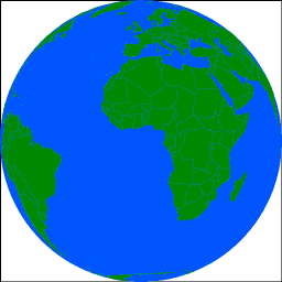
The basic concepts to generate an image like this is to use a dataset containing the world countries (as polygons or multipolygons) and to use an orthographic projection. By varying the longitude, we will mimic the rotation of the Earth. The projected coordinates will then be scaled to fit the required GIF size.
Parsing input data
Multiple libraries are available to parse geographical data. If you have the possibility to use CGO, the easiest way is to use a wrapper around GDAL/OGR. They are mainly based on the github.com/lukeroth/gdal package. It requires to have the GDAL shared library available at runtime.
Otherwise you may use pure Go libraries which are available for some common formats:
- Shapefile: https://github.com/jonas-p/go-shp and its forks
- GeoJSON
A GeoJSON parsing package is as simple as defining the 3 struct as
bellow and using the encoding\json standard package.
|
|
On the other side, no pure Go GML decoding libraries are available. The format is heavily based on inheritance and substitutions concepts. Thus it is an open challenge for everyone who wants to translate it to the Go philosophy.
Reprojecting data
The easiest way to manage reprojection of data is by using the PROJ4 C library. It can be done either using a shared library (github.com/pebbe/go-proj-4/proj) or by including the C code of the PROJ4 library inside a Go package (github.com/xeonx/proj4).
The C code is made to operate on an array of double. Using the “unsafe” package, it is possible to get pointers to members of Go structs and size of Go structs, making possible to operate directly on a Go slice of struct having X and Y members.
|
|
Creating images
github.com/llgcode/draw2d is a pure go 2D vector graphics library. After choosing a backend (image, pdf, …) you can setup a transformation matrix and start drawing in your own coordinates system. In our case we want to have the center of our coordinates system at the center of the image and a scale such that the earth will use as much space as possible.
|
|
Conclusion
A few geospatial projects (for example imposm) have started transitionning from C/C++ or Python to Go. The ecosystem is still young but, thanks to cgo, interoperability with existing libraries is easy.
Some libraries are being developed aiming at pure Go manipulation of geographical data. I may cite:
- github.com/paulmach/go.geo focused on server side manipulation. It includes algorithm such as clustering or GeoHash.
- github.com/ctessum/geom: geometry objects that can be encoded, decoded, reprojected, …
- github.com/twpayne/go-geom: fast and GC-efficient Open Geo Consortium-style geometries, including encoding and decoding from WKB.
Fo now there is no pure Go implementation of the OGC Simple Feature specification, and still less of the GML specification heavily based on inheritance concept. Go packages tends to solve specific problems faced by developpers and let the generic solution to other languages.
Source code
The whole source code used to generate the GIF is available at https://github.com/xeonx/earth